OUR SERVICES
Precision Data.
Safer Operations.
Reduced Risk.
At Gas Recon, we deliver advanced field services that combine precision data collection, geospatial intelligence, and efficient execution to support pipeline integrity, regulatory compliance, and environmental performance. Our solutions are designed to scale across distribution and transmission networks while providing clear, actionable insights.

Gas Leak Detection
We inspect natural gas networks to detect, classify, and document leaks across your infrastructure.
-
Detection of leaks at actionable threshold
-
Georeferenced leak locations with supporting imagery
-
Prioritized reporting to support rapid response and repair
Reduce risk
Minimize emissions
Maintain regulatory compliance

Enhance visibility
Protect assets
Ensure ongoing regulatory compliance
We inspect pipeline right-of-ways to identify, document, and monitor conditions that may impact the integrity and accessibility of your infrastructure.
-
Monitoring of vegetation, encroachments, and surface conditions
-
Identification of potential risks to pipeline integrity
-
Georeferenced observations with supporting imagery
-
Clear, prioritized reporting to support maintenance and compliance
Right of Way (ROW) Survey
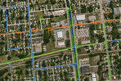
Line Locate & Pipeline Network Mapping
We accurately locate and map underground pipeline infrastructure to provide clear, reliable insight into your network.
-
Precise line locating with advanced tools
-
High-accuracy GPS mapping of assets
-
GIS-ready data for easy integration
-
Clear deliverables for planning and compliance
Improve data accuracy Reduce risk of third-party damage
Support informed decision-making

Depth of Cover Assessment
We measure and map pipeline depth of cover to identify areas of exposure risk and support system integrity.
-
Accurate depth measurements along pipeline corridors
-
Identification of low cover and potential risk areas
-
Georeferenced data with supporting imagery
-
Clear reporting to guide maintenance and remediation
Protect infrastructure
Reduce risk
Maintain regulatory compliance
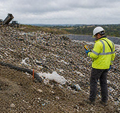
Surface Emissions Mapping
We detect and map gas emissions across a range of environments, including landfills and facilities, to provide clear insight into fugitive leaks and system performance.
-
Detection of methane and other target gases
-
High-resolution, georeferenced surface mapping
-
Identification of emission sources, trends, and hotspots
-
Actionable reporting to support mitigation and compliance
Improve visibility
Reduce emissions
Support regulatory requirements across diverse applications
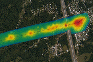
Aerial Methane Detection
We use advanced aerial sensors to rapidly detect and map methane emissions across large areas with high efficiency.
-
Wide-area methane detection using aerial platforms
-
High-resolution, georeferenced emission mapping
-
Rapid coverage of pipelines, facilities, and remote assets
-
Actionable insights to prioritize inspection and repair
Cover more ground
Detect leaks faster
Reduce emissions at scale